December 2022
Liton Chakraborty
Daniel Henstra
Jason Thistlethwaite
Andrea Minano
Yuvna Apajee
Daniel Scott
1) Rationale (e.g., What is the problem?):
The knowledge of nationwide flood exposure analysis on critical infrastructure (CI) and healthcare facilities is incomplete and mostly unknown in Canada. Assessing flood exposure of health and safety-related CI is essential for effective emergency preparedness in the era of climate change and frequent extreme weather events. Such an assessment also helps understand the ability of CI to deliver services during an emergency. Studies to address the current exposure of assets to flood hazards are limited, despite the considerable threat that flooding poses to communities and the geographic dispersion of health and safety-related CI facilities across the country. This study aims to identify health and safety facilities exposed to flood hazards and map their locations. This study adds to the Canadian literature on flood risk assessment by measuring and quantifying flood exposure of health and safety-related CI to generate evidence and a primary knowledge base to support allocating scarce public resources to reduce potential service disruptions.
2) Approach (e.g., What are you doing to address the problem?):
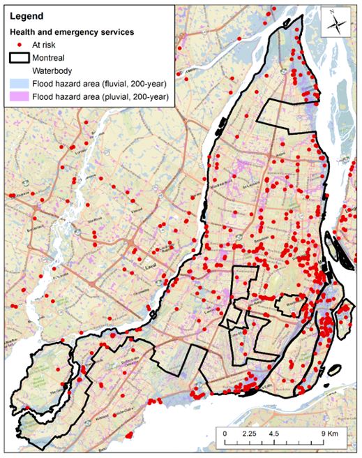
The study employed geospatial datasets to identify the facilities exposed to surface water, riverine, and coastal (storm surge) flooding. Flood hazard areas were determined based on geospatial datasets of JBA Risk Management (JBA). To detect health and emergency (H&E) service facilities at risk across Canada, a spatial analysis was performed in ArcGIS by employing flood hazards data for Canada from JBA, Canadian H&E facility location data from DMTI Spatial Inc., and the 2016 Canadian census boundary files from Statistics Canada. By using flood recurrence intervals of 20-, 50-, 100-, and 200 years and their corresponding annual exceedance probability scheme, flood hazard exposure was categorized into five groups: very high, high, moderate, low, and very low risk. The results were aggregated at the provincial scale and assessed across ten communities of interest, as determined through Health Canada’s HealthADAPT program. Combining a GIS-based map of H&E facility locations with flood maps, the study revealed the number of H&E facilities that could potentially experience disruptions due to their exposure to fluvial, pluvial, and coastal flood hazards.
3) Results and Discussion (e.g., What did you or do you expect to learn?):
The results of the national-scale analysis suggested that 16.8% of all H&E service facilities were at risk of flooding when flood defenses were not considered. Fluvial flooding was the dominant hazard in high-risk H&E facilities across several provinces. Most critical facilities exposed to flood hazards were healthcare services (e.g., hospitals, clinics, dental services) than fire or police services. Across all provinces and territories, Ontario had the highest number of at-risk H&E facilities subject to pluvial flood hazards, and Yukon had the highest percentage of H&E services both at-risk and at high risk of flooding. The second most significant percentage of at-risk and high-risk H&E facilities was found in Alberta, where pluvial flooding was the dominant hazard. Among ten HealthADAPT communities, Montréal had the highest number of at-risk H&E service facilities exposed to flood hazards. The percentage of at-risk critical facilities in eight communities of the HealthADAPT program was lower than the national average of 15.2%.
4) Management/Policy Implications (e.g., Why does it matter?):
Findings would support developing strategies for adaptation and health system resilience to climate change impacts and enhancing national strategy for critical infrastructure resiliency in Canada.
Keywords (Max 5):
Canada; Critical Infrastructure; Exposure Assessment; Flood; Healthcare Facilities